
Chongqing, China: Practical Path of AI-empowered IBFWS Governance Framework
As a mega-city integrating large urban areas, rural regions, mountainous terrain, and reservoirs, Chongqing faces unique challenges including imprecise hazard risk assessment, inadequate early warning granularity, and insufficiently targeted emergency plans. These risks are further exacerbated by high population density and complex urban governance. To address the demands of disaster prevention and reduction, Chongqing has integrated governance mechanisms with technologies such as artificial intelligence (AI) to transform the Impact-Based Forecasting and Warning Service (IBFWS) from a theoretical framework into practical disaster response capabilities. This has achieved a paradigm shift from fragmented, inefficient risk management to integrated, intelligent governance.
Under the overall coordination of the local Committee for Disaster Prevention, Reduction, and Relief, with technical support from the meteorological department and participation of relevant authorities including the Municipal Bureau of Big Data Development, Emergency Management Bureau, Water Resources Bureau, and Bureau of Planning and Natural Resources, the "44NN" early warning response protocol has been established.
Core Governance Framework
Built on the four-stage forecasting and early warning time frame of "24 hours → 6 hours → 2 hours → real-time", the core framework consists of three components:
Establish a vertical coordination mechanism across "Municipality → District/County → Town/Sub-district → Village/Community/Grid", clarifying response responsibilities for each administrative unit (e.g., municipal-level overall coordination, grid-level on-site evacuation).
N typical disaster scenarios: Covering hazard types such as floods and droughts, with differentiated response plans tailored to urban, rural, and other contexts.
N-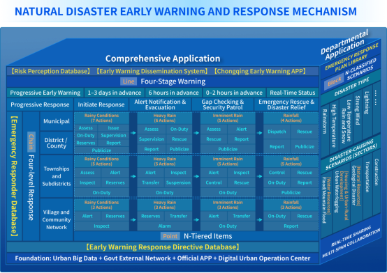
tiered task items: Matching differentiated action plans to early warning levels.
Response Action Examples (Refined Version)
Taking the orange early warning for heavy rain in the next 6 hours as an example, units at all levels carry out responses in accordance with procedures:
1. Municipal Bureau of Planning and Natural Resources (Municipal-level Response)
l Conduct dynamic risk assessment, delimit key towns (sub-districts) and small river basins, and issue point-to-point short-term early warnings;
l Alert and notify responsible persons of district/county bureaus under orange or higher early warnings, and inspect on-duty personnel and "Four Key" grid personnel via systems, work groups, video dispatching, and phone calls;
l Dispatch key guidance teams and technical forces to the grassroots, dynamically deploy ministerial and municipal-level expert teams to station in key districts/counties and regions, and assist local authorities in hazard inspection and disaster emergency response;
l Strengthen information collection, submission, and publicity guidance, conduct real-time statistics on prevention and response work, release early warnings through omni-media platforms, and follow up on disposal progress.
2. Shuangbei Sub-district, Shapingba District (Town/Sub-district)
l Village (community) cadres and grid workers: Immediately notify residents to take precautions, strengthen inspections of key locations such as the vicinity of Zhanjiaxi and landslide-prone areas of Guabang Mountain; promptly handle hidden dangers if found, report in accordance with regulations, and feed back implementation status within 2 hours;
l Responsible persons for flood control and drought relief risk points: Promptly forward early warning information, conduct publicity and guidance for residents, carry out hazard inspections in the Jialing River basin and Zhanjiaxi River channel within the jurisdiction; promptly take measures and report if problems are found.
AI-empowered Technical System
Chongqing has constructed a "Four Intelligences" technical architecture to implement the "44NN" early warning response protocol:
Intelligent Hazard Identification: Integrate 42 types of risk data (e.g., urban public utilities, transportation infrastructure) via cloud-based APIs, develop AI forecasting models, and generate town/sub-district level, minute-level risk warnings.
Intelligent Response Matching: Leverage urban governance large models to build an alert-action matching engine (1,200 matches/second). Through AI-driven optimization, over 219,000 response measures have been formulated, and 314,700 grassroots responders have been categorized into 8 professional roles.
Intelligent Information Delivery: Embed modular services into sectoral platforms, push alerts to 870,000 APP users, and achieve full public coverage of critical warnings within 15 minutes through 19 channels.
Intelligent Effect Evaluation: Establish an indicator system including alert coverage rate and response timeliness, conduct real-time monitoring and post-event reviews, and iteratively optimize models and response protocols.
Implementation Results
In 2025, despite 28 severe precipitation events (10 more than the average year), key disaster indicators have dropped significantly: affected population (-38.9%), emergency evacuations (-54.13%), damaged houses (-49.04%), affected crop area (-50.61%), and direct economic losses (-62.77%).
The "44NN" early warning response protocol provides clear institutional guarantees, while AI technologies address technical bottlenecks such as data integration and rapid matching, effectively promoting the transformation of IBFWS from "forecasting" to "action".