



Tropical System in the Bay of Bengal to Develop into a Cyclonic Storm
India, Nepal, and Other Areas Experience Heavy Precipitation
At 00:00 UTC on October 26, the center of the Bay of Bengal deep depression was located in the central Bay of Bengal, with maximum sustained winds of force 7 (15 m/s) near the center and a central minimum pressure of 1002 hPa. It is expected to move westward at approximately 15 km/h and intensify into a cyclonic storm within the next 12 to 24 hours, potentially reaching the strength of a severe cyclonic storm or a very severe cyclonic storm. The system is forecast to make landfall along the eastern coast of India during the day on the 28th. After landfall, it will turn northward and gradually weaken (Figure 1).
Under its influence, from October 27 to 31, heavy to torrential rain is expected in eastern and northern India, Nepal, western Bhutan, western Bangladesh, and western Myanmar, while intense to extreme downpours will lash the northeastern Indian Peninsula. Across most of these areas, accumulated rainfall will range from 50 to 90 mm. In parts of India such as Odisha and northern Andhra Pradesh, accumulations will reach 130 to 250 mm, with localized amounts exceeding 300 mm (Figure 2). Meanwhile, winds of force 7 to 9, locally reaching force 10 to 12 with gusts of force 13 to 14, are forecast over the central and western Bay of Bengal, as well as the southern coast of Odisha and the central to northern coast of Andhra Pradesh (Figure 3). Additionally, high-altitude areas including northern Karnali Zone and northern Bagmati Zone in Nepal will experience heavy to torrential snow, with localized intense to extreme snowstorms. Precautions should be taken against secondary disasters such as flash floods, landslides, and debris flows triggered by the heavy precipitation, as well as the adverse impacts of strong winds on offshore operations, land-based infrastructure, and road traffic.
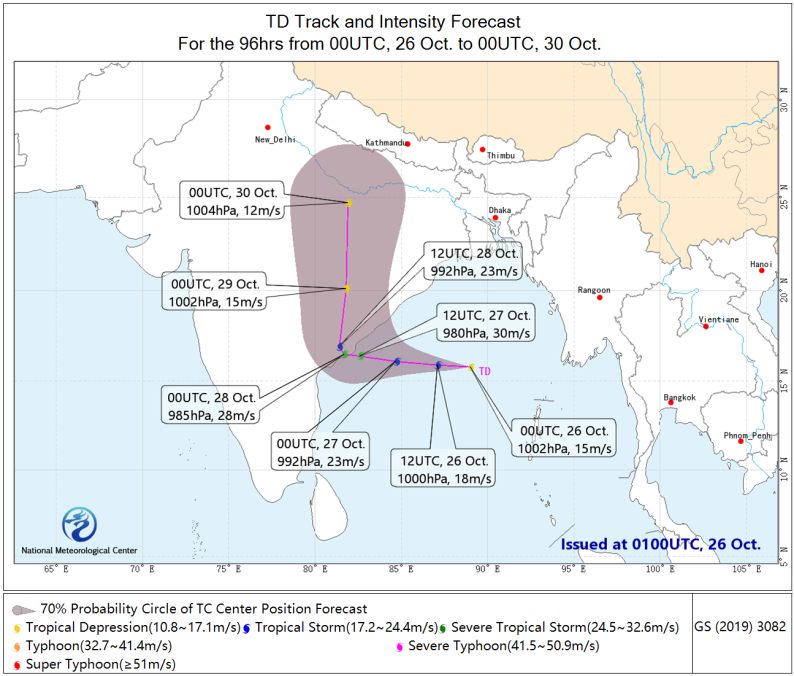
Figure 1. 96-Hour Probabilistic Track Forecast for the Tropical System (00:00 on October 26 to 00:00 on October 30, 2026, UTC)
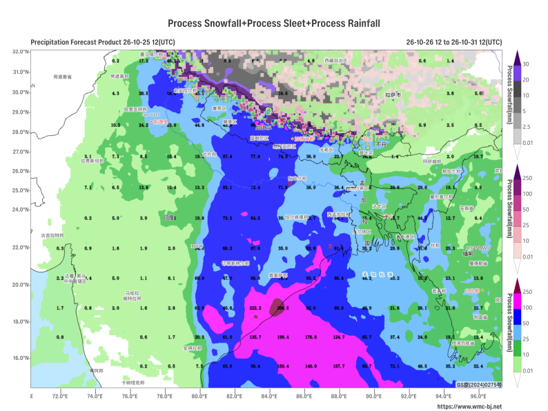
Figure 2. Forecast of Cumulative Rain and Snow from 12:00 on October 26 to 12:00 on October 31, 2026, UTC (Unit: mm)
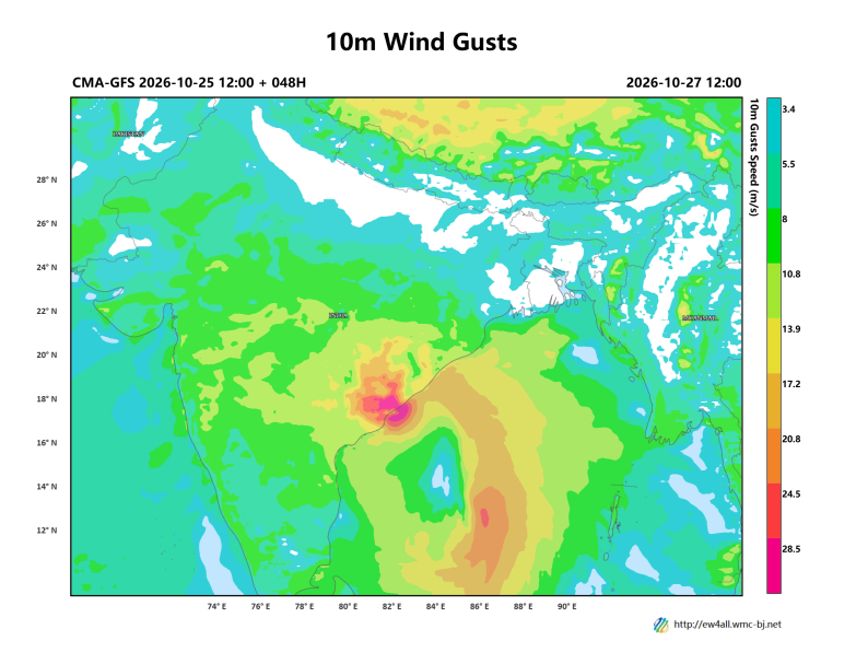
Figure 3. 24-Hour Maximum Gust Forecast at 12:00 UTC on October 27, 2026 (Unit: m/s)
https://www.wmc-bj.net

Author: Huo Da, Xu Yinglong Reviewer: Lian Zhihua
English reviewer:Wang Yi Issue approver:Dai Kan