



Current Fire Situation Along the China-Mongolia Border and 3-Day Weather and Risk Forecast
Since October 8, 2026, the Fengyun-4C (FY-4C) satellite has detected multi-wildfire activities along the China–Mongolia border, with the fire continuing to spread. At 14:40 Beijing Time (BJT) on October 12, 2026, FY-4C observations revealed that the northern fire hotspot was centered at 119.73°E, 47.05°N (indicated by the red arrow in Figure 1), while the southern fire hotspot had approached the China–Mongolia border, with its center located at 119.88°E, 46.67°N (indicated by the yellow arrow in Figure 1). Smoke plumes originating from the active fire areas were observed drifting southeastward. According to the FY-4C border high-temperature point monitoring map at 18:00 (Figure 2), the fire points are extremely close to China's border areas.Satellite remote sensing estimates indicated that the burned area had reached approximately 5,050 km². Minute-scale observations from multi-source geostationary satellites during October 11–12 revealed that the wildfire continued to spread, with the maximum hotspot-affected area exceeding 160 hectares at 12:40 Beijing Time (BJT) on October 11 (Figure 3).
From the night of October 12 to 15, under the influence of an upper-level ridge, eastern Mongolia and the central China-Mongolia border region will experience predominantly dry and windy weather (Figure 4). Most areas will see west to northwest winds of force 4 to 6, with gusts of force 7 to 8, and locally reaching force 9 (Figure 5). Relative humidity will remain low (Figure 6), keeping grassland surface fuels dry and sustaining high to extremely high meteorological fire danger levels. Overall precipitation will be scarce (Figure 7), offering limited effectiveness in suppressing fire conditions. The combination of strong winds and low humidity means existing fire spots in Mongolia face risks of rekindling, spotting, and cross-border spread. Particular attention must be paid to preventing the boosting effect of high winds on fire spread.
Additionally, from October 13 to 15, the weather in eastern Inner Mongolia, including Xilin Gol and Hulunbuir, is expected to be predominantly sunny with intermittent clouds, with temperatures ranging from -7°C to 12°C. On October 13, winds will be at force 4 to 5, with gusts reaching force 6, predominantly from the northwest. From October 14 to 15, wind forces will be 2 to 4, shifting from northwesterly to easterly directions. Consequently, the meteorological risk level for forest and grassland fires will be relatively high in parts of central and eastern Inner Mongolia. Specifically, localized areas—including central and southern Hulunbuir, central and northern Hinggan League, northern Tongliao, northern and southwestern Chifeng, and southeastern Ordos—will face a high risk of forest and grassland fires (Figure 8).
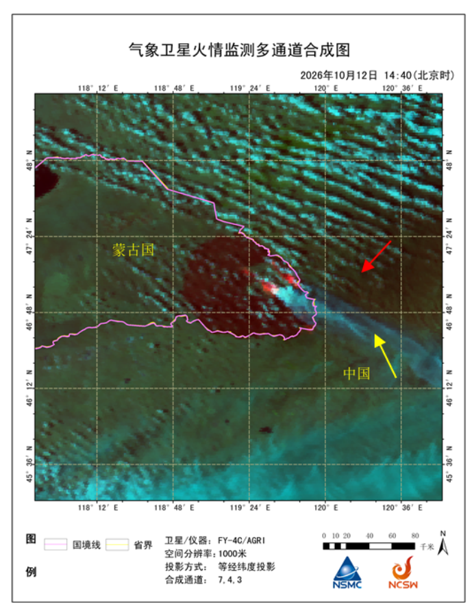
Figure 1. FY-4C Multichannel Composite Image for Wildfire Monitoring at 14:40 Beijing Time (BJT) on October 12, 2026.
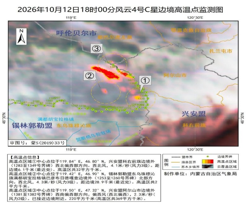
Figure 2. FY-4C High-Temperature Spot Monitoring
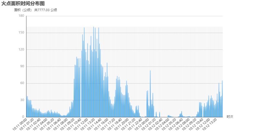
Figure 3. Temporal Evolution of Wildfire Activity in the Active Fire-Affected Area in Mongolia.
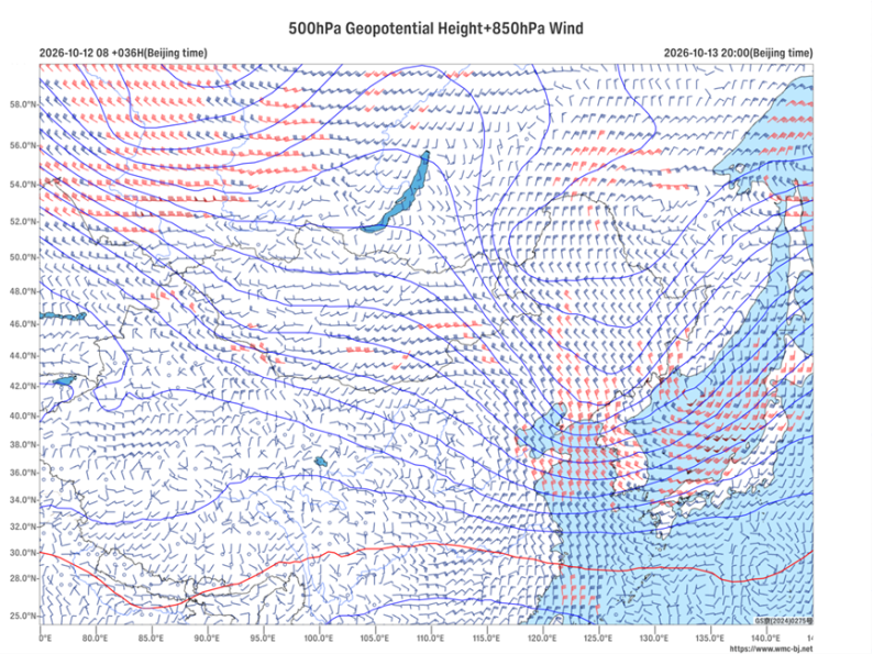
Figure 4. Forecast of 500 hPa geopotential height (contours, units: dagpm) and 850 hPa wind field (barbs, units: m/s) at 20:00 BJT on October 13, 2026
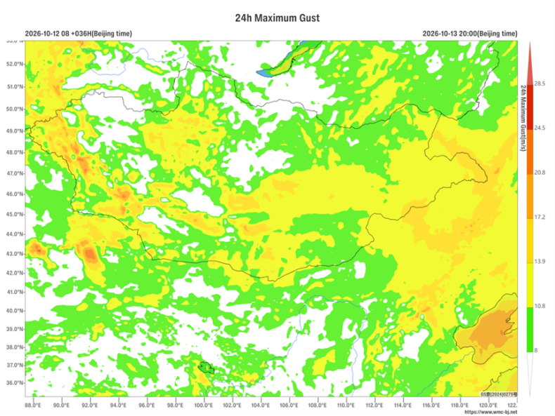
Figure 5. 24-Hour Maximum Gust Forecast at 20:00 on October 13, 2026 (Beijing Time) (Unit: m/s)
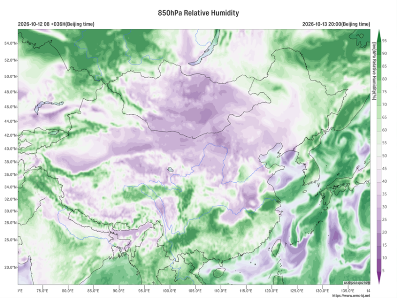
Figure 6. Forecast of 850 hPa Relative Humidity (Unit: %) at 20:00 BJT on October 13, 2026
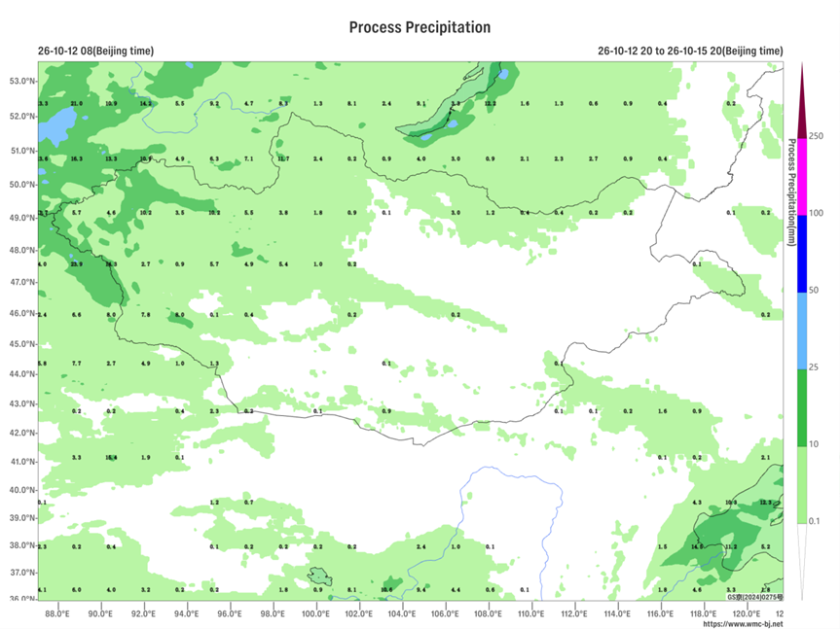
Figure 7. Forecast of Accumulated Precipitation from 20:00 on October 12 to 20:00 on October 15, 2026 (Beijing Time) (Unit: mm)
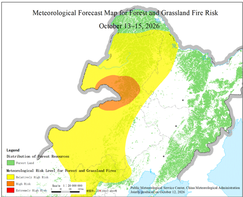
Figure 8. Meteorological Forecast Map for Forest and Grassland Fire Risk in Key Regions from October 13 to 15, 2026
Major Participating Institutions: National Meteorological Center, National Satellite Meteorological Center, Public Weather Service Center of China Meteorological Administration, Inner Mongolia Autonomous Region Meteorological Bureau

Author: Xiong Minquan, Zhu Lin, Yang Xiaodan, Li Bin Reviewer: Xie Jin
English reviewer:Wang Yi Issue approver:Dai Kan