
Global Severe Weather Watch and Forecast Bulletin
Blizzard hits Russia
'Meghan' makes landfall on Indian peninsula
1.Observation
From December 1 to 4, affected by the eastward movement of the European vortex and trough, most parts of Europe experienced a large range of cooling and rain and snow weather process, among which, Central Europe, northern southern Europe and Eastern Europe appeared 2 to 3 days of continuous snow or sleet, southern Poland, the Czech Republic, Slovakia, Belarus, western and central parts of Russia appeared large snow, local heavy snow; Parts of Western Europe, eastern southern Europe and other places have light to moderate rain, local heavy rain or torrential rain.
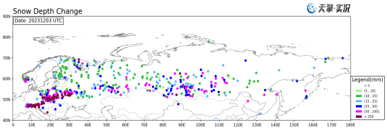
Figure 1. Depth of snow increase in Europe on December 3 (UTC)
Under the influence of the eastward movement of the European vortex and the stable Northeast Asian vortex, the average temperature in Siberia from west to east of Russia dropped by 6-10 ° C from 2 to 4, and the local temperature dropped by more than 14 ° C. In the morning of 4, the temperature in many stations in Siberia dropped below -50 ° C. In the morning of 5, the Sakha Republic recorded a low temperature of -58.7 ° C. This is close to the record low temperature of -59.7 ° C since the 21st century.
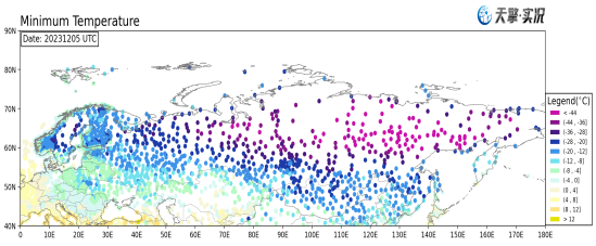
Figure 2. Minimum temperature in Russia early on December 5 (UTC)
On December 5, Cyclone "Meechan" landed in the southeast of the Indian Peninsula, affected by its body and peripheral circulation, from 2 to 6 days in the southeastern coastal areas of India, large to heavy rain, local heavy rain, including 5 days in Tamil Nadu local large-scale flooding and waterlogging.
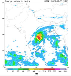
Figure 3. Daily rainfall over Peninsular India on December 5 (UTC) (0500-0600)
2.Forecast
It is expected that under the influence of the development of a ridge of high pressure in Eastern Europe, the temperature in western Russia will rise, and the snow in most parts of Siberia will be significantly weakened.
1