1.Introduction
The monsoon brings heavy rain and floods to parts of Bangladesh and India. It was reported that, Bangladesh is facing the worst flood in 20 years. Rainfall and floods have killed 68 people and trapped 4million people in Bangladesh. The death toll from floods in Assam state of India has reached 135, and 2.2 million people are suffering from floods.
2. Satellite monitoring results
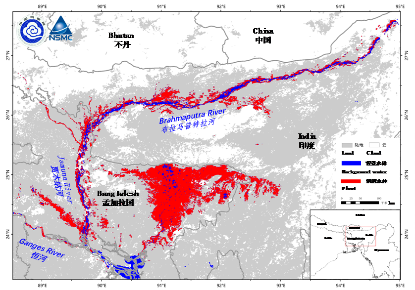
Heavy rains caused widespread flooding. We have used FY-3D/MERSI data (observed in June 24-29) to monitor the flood waters in the Brahmaputra River Basin in Northeast India and Bangladesh. The result shows there are about 17500 square kilometers of flooded area (red area in Fig. 1) caused by the heavy rainfall.
The flood waters are distributed on both banks of Brahmaputra River in India, and Assam state along the river has suffered serious flood disaster. It is estimated that the area of farmland affected by flood water in the figure is about 2000 square kilometers. At the same time, the Jamuna River in Bangladesh is also affected by serious floods, especially in the low-lying areas in the northeast of Bangladesh. It is estimated that the area of farmland affected by flood waters in Bangladesh is about 7000 square kilometers.

Fig.1 The flood monitoring results from FY-3D/MERSI
(June 24-29, 2022)
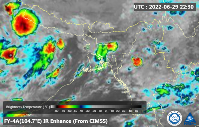
The convective cloud also monitored by FY-4A meteorological satellite. The monitoring image of FY-4A at 22:30 (UTC time) on June 29 (Fig. 2) shown strong convective cloud cluster appeared over northeast Bangladesh and north India, and the TBB (temperature of brightness blackbody)was below -70 oC.

Fig.2 IR Enhanced Image of FY-4A, acquired at 22:30 (UTC) on June 29, 2022.
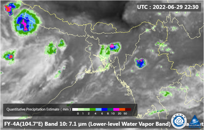
Quantity Precipitation Estimation (QPE) results shown the amount of precipitation reached more than 10mm/h (Fig.3). It is forecast that light rain/thunder showers is likely to occur over the area, and we will pay close attention to it.

Fig.3 Quantity Precipitation Estimation (QPE) of FY-4A, acquired at 22:30 (UTC) on June 29, 2022.
(Source: NSMC)

