
"FINA" to Impact Northern Coastal Regions of Australia
In the past 24 hours, Tropical Cyclone "FINA" has intensified from Category 7 to Category 10. It is currently located approximately 380 kilometers northeast of Darwin in northern Australia, moving east-southeast at a speed of around 10 kilometers per hour. The cyclone's intensity is expected to remain stable or slightly increase (Figure 1).
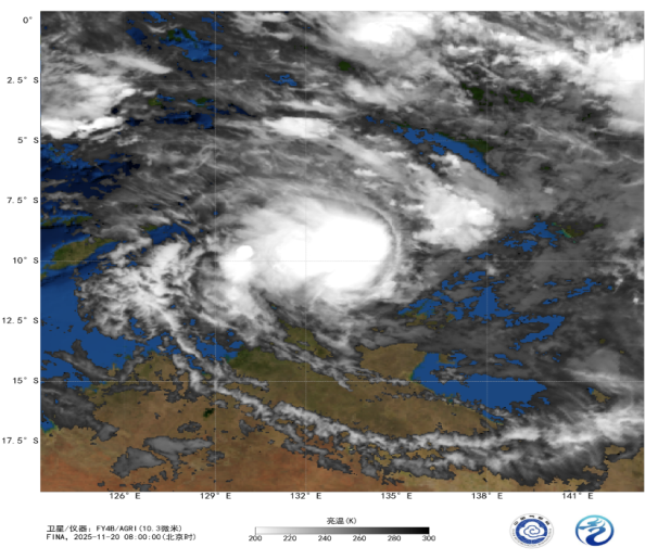
Figure 1 Satellite Infrared Monitoring Image (UTC, November 20, 2025, 00:00)
It is forecasted that from the evening of the 20th, strong winds and heavy rain will impact the coastal areas from the Cobourg Peninsula to the Warruwi region in northern Australia, accompanied by destructive gusts. On the 21st, the influence of the storm will gradually extend westward to Maningrida and the Tiwi Islands. By the 22nd, the adverse weather will stretch from Darwin Harbour eastward to Gumbalanya. These regions are expected to experience heavy rainfall, with localized areas at risk of flash flooding. During high tide periods, the Tiwi Islands to Maningrida area may face abnormally high tidal levels, accompanied by destructive waves and hazardous flooding.

Figure 2: Accumulated Precipitation from 00:00 on November 20 to 12:00 on November 23 (UTC, Unit: mm)

Figure 3: Maximum Gust Speed (Unit: m/s) for 6 Hours at 12:00 (UTC) on November 21
![]()
Author: Yan Dachun Reviewer: Zhou Ningfang
English reviewer: Wang Yi Issue approver: Dai Kan