

Central and Southern Australian Will Experience Strong Winds, Cooling and Rainfall
From October 21 to 23, influenced by the eastward movement of an upper-level trough, a weather pattern characterized by strong winds, cooling, and rainfall will develop from west to east across central and southern Australia. Some areas will experience a temperature drop of 8 to 12°C, with localized exceeding 14°C (Figure 1). This will be accompanied by winds of 5 to 6 on the Beaufort scale, with gusts reaching 7 to 8, and locally as high as 9 to 10 (Figure 2). The southern and southeastern coastal regions of Australia will see light to moderate rain, with localized heavy downpours (Figure 3). Precautions are advised against the adverse impacts of these strong winds, cooling, and rainfall on local power transmission and maritime transportation.

Figure 1 48-hour Temperature Change Forecast at 2 meters above ground level as of 1200 UTC on October 22 (Unit: °C)

Figure 2 24-Hour Maximum Gust Forecast at 12:00 UTC on October 22 (Unit: m/s)
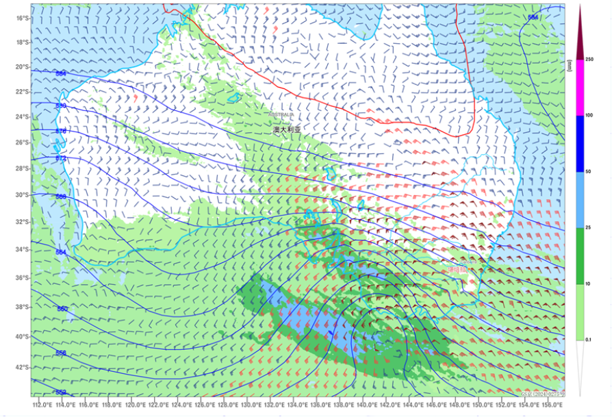
Figure 3 24-hour Rainfall Forecast (Unit: mm), 500 hPa Geopotential Height, and 850 hPa Wind Field as of 00:00 UTC on October 22
![]()
Author: Min Ying Reviewer: Niu Ruoyun
English reviewer: Wang Yi Issue approver: Dai Kan