
The Tropical Depression over the South China Sea is Expected to Bring Strong Winds and Heavy Rain to Vietnam
A tropical depression formed in the central South China Sea on the morning of June 10th. At 8:00 AM (BJT), its center was located approximately 285 kilometers southeast of Sansha City, Hainan Province, China (near 15.8°N, 114.8°E), with the maximum wind speed near the center reaching 7 levels (15 m/s) and the minimum central pressure at 1000 hPa (Fig.1). It is expected that this depression will move westward at a speed of 10 kilometers per hour, gradually intensifying and potentially developing into a typhoon within 24 hours. It will approach the coastal areas from southern Hainan Island to western Guangdong Province, China, and is likely to make landfall around June 13th as a severe tropical storm to typhoon (10-12 levels, 25-33 m/s). After landfall, its intensity is expected to gradually weaken.
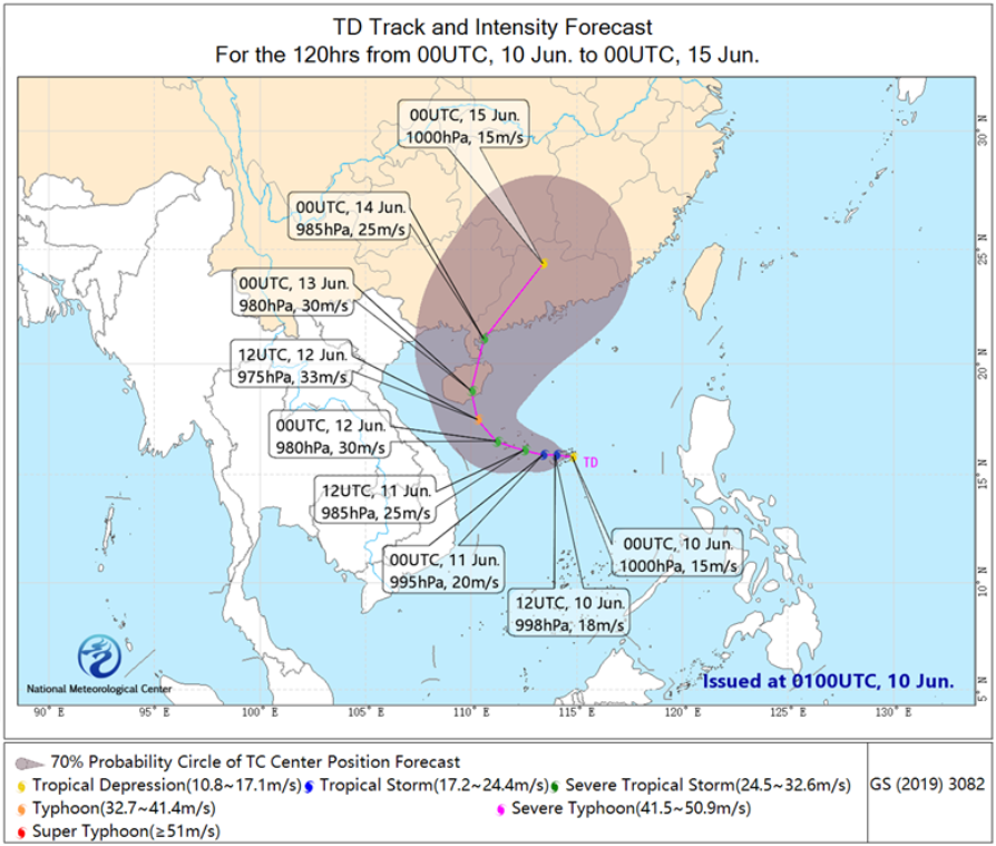
Figure 1 The South China Sea TD Track and Intensity Forecast for the Next 120hrs
Affected by this weather system, it is expected that from June 11 to 13, parts of central and southern Vietnam, as well as the northeastern regions, will experience moderate to heavy rainfall. Specifically, localized heavy downpours are anticipated in areas including Ha Tinh Province, Quang Binh Province, Quang Tri Province, and Quang Nam Province. The cumulative precipitation in most of these regions is forecasted to be between 30-45 mm, with some areas receiving 60-80 mm, and locally exceeding 110 mm (Fig.2). Additionally, from June 12 to 14, the Beibu Gulf and the northern coastal areas of Vietnam will experience strong winds of 8 to 9 on the Beaufort scale, with gusts reaching 10 to 11. Attention should be given to the potential for localized flooding or landslides triggered by the heavy rainfall.
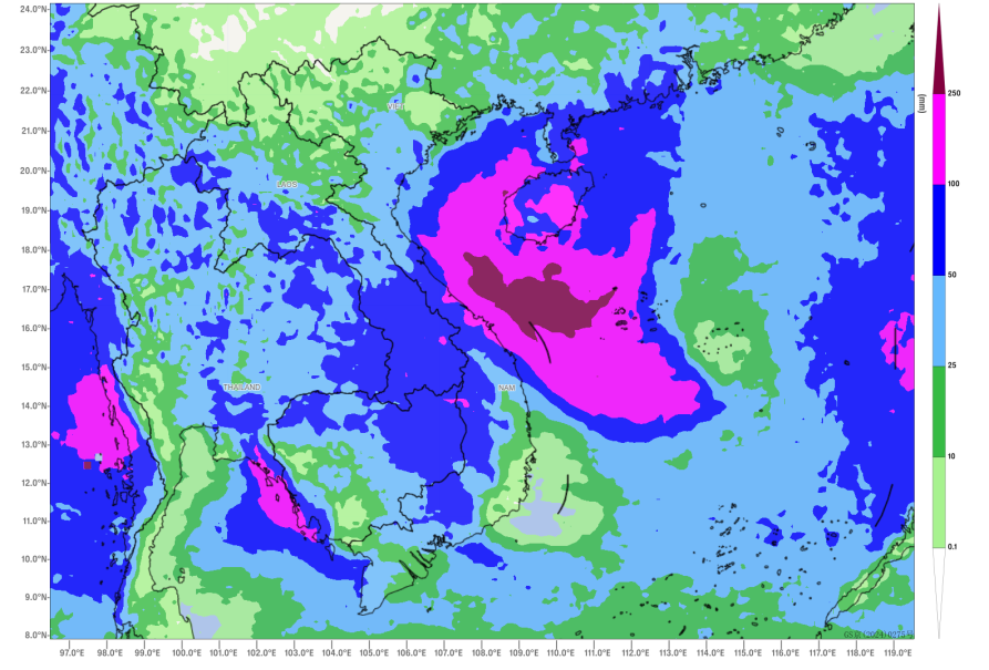
Figure 2 Accumulated Precipitation from 12 UTC June 10 to 12 UTC June 13, 2025 (Unit: mm)
![]()
Author: Hu Yingying Reviewer: Wang Guanlan
English reviewer:Wang Yi Issue approver:Dai kan