
Extreme heavy precipitation occurs in Southern China
Since April 19th, 2024, continuous heavy rainfall and severe convective weather processes have been observed in the southern parts of the Jiangnan regin and South China, characterized by large accumulated rainfall, high degree of overlap in heavy rainfall areas, extreme rainfall intensity, and distinct severe convective features.
Eastern Guangxi, central and northern Guangdong have experienced heavy rain for 2 to 3 consecutive days, with the maximum hourly rainfall exceeding 50 mm/h, and locally reaching 140.8 mm/h in Beihai, Guangxi. In some of these regions, thunderstorms with gales of 8 to 10 grade and locally 11 grade occered,along with locally moderate-intensity tornadoes (equivalent to maximum instantaneous wind speeds reaching up to Grade 15) were reported. The total rainfall during this process reached 200 to 280 mm, locally exceeding 300 mm (Figure 1). A total of 17 national meteorological observation stations in Guangdong and Guangxi broke the historical maximum daily rainfall records for April.
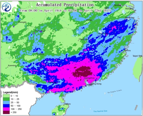
Figure 1. Observed accumulated precipitation from 08:00 on April 19th to 07:00 on April 22nd, 2024 (Unit: mm)
It is predicted that on the 22nd, heavy rainstorms will still be seen in most parts of Guangdong and southern Fujian. For some areas in the southeastern part of Guangdong, very heavy rainfall may occur (100–130 mm, Figure 2). The maximum hourly rainfall will be 30–50 mm/h, with locally over 70 mm/h. Parts of the aforementioned regions may still experience thunderstorms with gales of 8–10 grade (locally more than 11 grade) or hailstorms . From the 23rd to the 24th, the rainfall will gradually weaken, but there will still be heavy rain in southeastern Guangdong and some other areas.
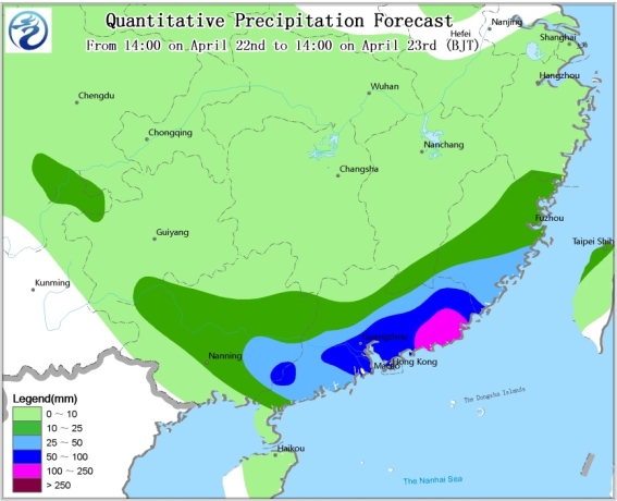
Figure 2. Quantitative precipitation forecast from 14:00 on April 22nd to 14:00 on April 23rd (Unit: mm)
![]()
Author: Huang Wei Reviewer: Yang Shunan
English reviewer:Ma Jie Issue approver:Dai Kan