Issued by: National Meteorological Center, CMA
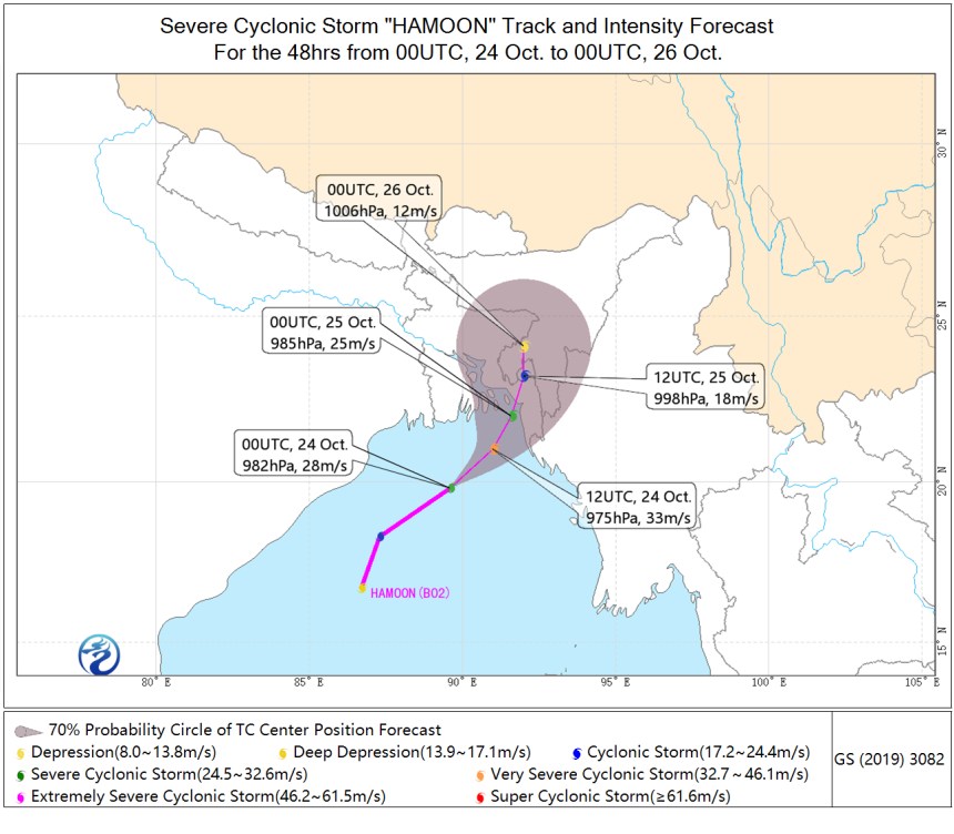
HAMOON was generated in the northern Bay of Bengal last night in local time and experienced rapid intensification (Bft-7 to Bft-10) in the last 24 hours. The center of HAMOON is located over the ocean about 335 km (19.8°N, 89.6°E) south by west to Borisal, Bangladesh with a maximum sustained winds of 28m/s (Bft-10) and central minimum pressure of 982hPa at 00:00UTC, Oct.24th,2023 .

According to the official forecast of CMA, HAMOON is expected to move northeastward with an averaged speed of 15~20 km/hr and intensify continually (Maximum to Bft-12) before making landfall in the southeast coast of Bangladesh in the morning of 25th Oct. Then it will move northward and collapse soon after landfall .
Due to the passage of HAMOON, the South coastal region Bay of Bengal will will have gale winds (Bft8~10) with stronger gust winds (Bft11~12) in the next 24 hours. The winds force will soon decrease in the daytime of 25th.In the next 24hr, the Southern Bay of Bengal will experience heavy rainfall successively, up to 100 to 200 mm in coastal region. Accordingly, the storm surge caused by HOMOON deserves more caution in the low-lying areas. (Xiang Chunyi, Zhou Qingliang)

 京公网安备 11040102700102号