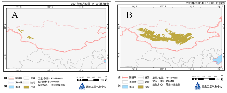
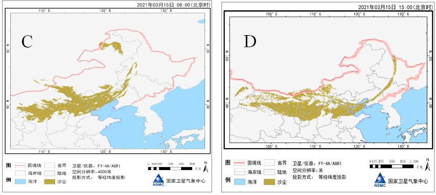
According to Fengyun meteorological satellite monitoring, on 14 March 2021, influenced by the strong Mongolian cyclone (Central sea level air pressure 980hPa) and its rear cold air, a strong SDS occurred in most of Mongolia, with the instantaneous wind force reaching 10-12 levels (Figure 1). On the night of the 14th, the cyclone moved to the south and the east, and the large-scale SDS event occurred in the Midwest of Inner Mongolia of China. On the afternoon (15th), the sand and dust appeared successively in the eastern part of Xinjiang, Inner Mongolia, Gansu, Ningxia, Shanxi, Hebei, Heilongjiang, Jilin, Liaoning, Beijing, Tianjin, and other places. In Inner Mongolia, western Gansu, northern Ningxia, northern Shanxi, northern Hebei, Beijing Tianjin, and other places, sandstorms or severe sandstorms occurred. In Inner Mongolia, northwest, North China and Northeast China, there is the strong wind of level 6-8, with gusts of level 10-11. Due to the influence of SDS, the minimum visibility of many places has decreased to less than 500 meters. Statistics results show that the process is the strongest one in China in recent 10 years. In Inner Mongolia, Gansu, Ningxia, northern Hebei, and Beijing, PM10 concentration exceeded 5000 μg/m3 and peaked in Beijing over 9000 μ g/m3. Until March 16, the widespread, super-strong Asian SDS event has influenced Northwest China, most areas of North China, the western part of Northeast China, and Yellow-Huai River regions, not seen for nearly a decade. The Sandstorms and strong sandstorms have affected parts of southern Xinjiang, Inner Mongolia, western Gansu, central and northern Ningxia, northern Shaanxi and Shanxi province, northern Hebei, Beijing. (WMO RSMC-ASDF BEIJING)


Figure 1 the SDS monitoring results from Fengyun meteorological satellite
(A: March 13,14:00 B: March 14 16:00 C: March 15 08:00 D: March 15 15:00, at Beijing time)

